[:pb]
The Belgian engineer was the head of the expedition that defined the territory of the new capital of the country. The gift was given to Rollemberg in solemnity at the Buriti Palace.
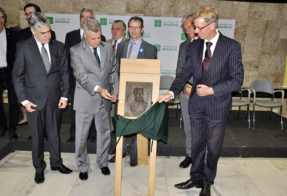
The government of Brasília received this Tuesday 17 a bronze plaque in honor to Luiz Cruls, the Belgian engineer and astronomer that was the head of the expedition to grub the Brazilian central plateau searching for new premisses for the capital of the country. The present was given by the Belgian embassy during the solemnity at the Buriti Palace.
The governor Rodrigo Rollemberg highlighted the importance of the honored for the history of Brasília. “Cruls have had a great insight, we are at a water cradle”, affirmed the head of the local Executive in reference to the region’s watersheds, like the Paraná, which’s source is in the Federal District. He added yet that the local characteristics like climate and relief contributed to the creation of the city.
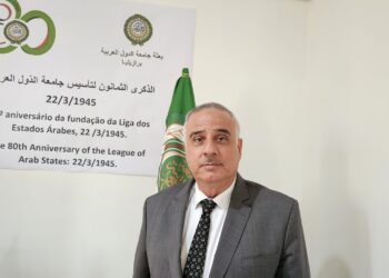
 “Brasília owns its existence to Cruls’ life”, said the secretary of culture Guilherme Reis, also during the same event. For the ambassador of Belgian Jozef Smets (photo), the relation of the European country with the Brazilian capital is important. “This is a multicultural city that receives a lot of diplomatic representatives”.
 The mayor of Diest – the city where Cruls was born – Jan Laurys (photo), affirmed that the Belgian county is small (58.2 square meters) and that the work of the engineer is an honor for the local population. “Over there everyone knows Luiz Cruls and his importance for Brasília and, now, over here they will also know a little about Diest”. The government of Brasília will still deliberate where the plaque will stand to be seen by the public.
There were present at the ceremony the representative of the Ministry of Foreign Affairs Carlos Perez; the artist that designed the plaque Luc de Blick; the president of the Cruls Cultural Memorial Center Pedro Jorge de Castro; the collaborator of the government and governor’s spouse Márcia Rollemberg; the head of the Civil House Sérgio Sampaio; the secretary of the Public Safety and Social Peace Márcia de Alencar; the secretary of Agriculture, Supply and Rural Development, José Guilherme Leal; the regional administrator of the Plano Piloto, Mark Pacco; and the Congressman Augusto de Carvalho; among other authorities.
History – In 1874, when he was 26 years old, Louis Ferdinand Cruls came to Brazil by curiosity and adventure. In the tropical country he became a naturalized citizen and altered his own name to Luiz Cruls. The Belgian was responsible to commanding the expedition that was later known as Cruls Mission, that was searching and exploring the national territory in order to transfer the capital from the coast to the center, as contained in the Constitution of 1891.
In the first Magna Carta of Brazil as a republic, there was delimited an area of 14.4 thousand square kilometers for the new capital to be placed. Cruls was the one who defined that the Federal District would be a quadrilateral and that would be around 160 by 90 kilometers. The division back in those days included the surrounding counties like Luziânia. The current territory of the Federal District is around 5.7 thousand square kilometers. The expedition with 23 members started in Pirenópolis and went to Formosa, where the explorers analyzed the fauna and flora of the Planalto Central.
Source: Jade Abreu, from Brasília Agency
Governo de Brasília ganha placa em homenagem a Luiz Cruls
Governo de Brasília ganha placa em homenagem a Luiz Cruls
Engenheiro belga chefiou expedição para definir território da nova capital do País. Presente foi dado a Rollemberg em solenidade no Palácio do Buriti
O governo de Brasília recebeu nesta terça-feira (17) uma placa de bronze em homenagem a Luiz Cruls, engenheiro e astrônomo belga que, em 1892, chefiou expedição para desbravar o Planalto Central brasileiro em busca de uma nova sede para a capital do País. O presente foi dado pela Embaixada da Bélgica, durante solenidade no Palácio do Buriti.
O governador Rodrigo Rollemberg ressaltou a importância do homenageado para a história brasiliense. “Cruls teve uma perspicácia muito grande, estamos no berço de águas”, afirmou o chefe do Executivo local, em referência às bacias hidrográficas da região; como a do Paraná, com nascente no Distrito Federal. Ele acrescentou que características locais como clima e relevo contribuíram para a criação da cidade.
“Brasília deve a sua existência à vida de Cruls”, resumiu o secretário de Cultura, Guilherme Reis, também durante o evento. Para o embaixador da Bélgica, Jozef Smets, a relação do país europeu com a capital brasileira é importante. “Esta é uma cidade multicultural que recebe muitos representantes diplomáticos”.
O prefeito de Diest — cidade onde Cruls nasceu— Jan Laurys, afirmou que o município belga é pequeno (tem 58,2 quilômetros quadrados) e que o trabalho do engenheiro é uma honra para a população local. “Lá, todos conhecem Luiz Cruls e sua importância para Brasília e, agora, aqui também conhecerão um pouco de Diest”. O governo de Brasília ainda vai decidir onde a placa ficará exposta para ser vista pelo público.
Compareceram à cerimônia o representante do Ministério das Relações Exteriores Carlos Perez; o artista plástico que criou a placa, Luc de Blick; o presidente do Centro Cultural Memorial Cruls, Pedro Jorge de Castro; a colaboradora do governo e esposa do governador Márcia Rollemberg; o chefe da Casa Civil, Sérgio Sampaio; os secretários da Segurança Pública e da Paz Social, Márcia de Alencar, e da Agricultura, Abastecimento e Desenvolvimento Rural, José Guilherme Leal; o administrador regional do Plano Piloto, Marcos Pacco; e o deputado federal Augusto de Carvalho; entre outras autoridades.
Histórico – Em 1874, aos 26 anos de idade, Louis Ferdinand Cruls veio para o Brasil por curiosidade e aventura. No país tropical, ele se naturalizou e alterou o próprio nome para Luiz Cruls. O belga foi responsável por comandar a expedição que ficou conhecida como Missão Cruls, que buscava explorar o território nacional para transferir a capital do litoral para o centro, como estava na Constituição de 1891.
Na primeira Carta Magna do Brasil como república, estava demarcada uma área de 14,4 mil quilômetros quadrados para a nova capital. Cruls foi quem definiu que o DF seria um quadrilátero e que teria cerca de 160 por 90 quilômetros. A divisão da época incluía municípios do entorno, como Luziânia. O atual território do Distrito Federal tem cerca 5,7 mil quilômetros quadrados. A expedição com 23 membros começou em Pirenópolis e seguiu até Formosa, onde os exploradores analisaram a flora e a fauna do Planalto Central.
Fonte: Jade Abreu, da Agência Brasília
[:]


